

A Northern Beaches Tunnel report released this week indicates pollution impacts near the tunnel openings will be “negligible” compared with existing air quality, but concedes more than 15 hectares of native vegetation will be removed and ecosystems likely affected along the Wakehurst Parkway.
The Northern Beaches Tunnel – or Beaches Link – Environmental Impact Statement (EIS) was placed on public display this week. Submissions will close on March 1.
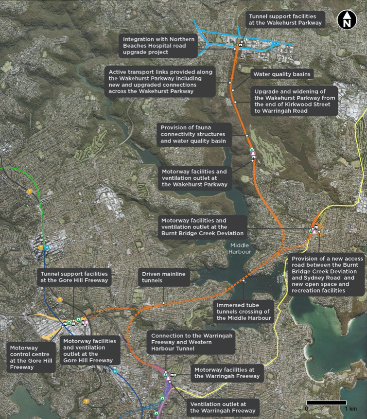
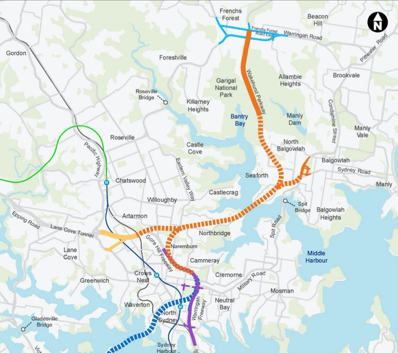
The Beaches Link, scheduled to start in 2023 and be completed by 2028, will have two portals (entries/exits) – one in Balgowlah and one in Seaforth – taking vehicles through 7kms of tunnels under Middle Harbour and the lower North Shore, connecting with the Warringah Freeway in Cammeray.
The project documents all allude to it being a tolled road, with users paying for the benefit of skipping notorious congestion points along the Spit and Military Road and forecasted time savings of up to an hour for the Dee Why to Airport commute. For a broader look at the project and expected commuter benefits, see our recent article on the topic.
But how will this “mega-project” affect residents of the lower Northern Beaches and what points of concern may call for community feedback during this EIS exhibition period?
First, let’s cover a few basics.
Where will the on/off ramps be?
There will be twin two lane ramp tunnels:
• Eastbound and westbound connections between the mainline tunnel under Seaforth and the surface at Burnt Bridge Creek Deviation, Balgowlah (about 1.2 kilometres in length) and,
• Northbound and southbound connections between the mainline tunnel under Seaforth and the surface at Wakehurst Parkway, Killarney Heights (about 2.8 kilometres in length)
There will also be an access road connection at Balgowlah between Burnt Bridge Creek Deviation and Sydney Road including the modification of the intersection at Maretimo Street and Sydney Road, Balgowlah.
What does an EIS do anyway?
Feedback from stakeholders on an Environmental Impact Statement is assessed and reported to the Minister for Planning and Public Space, who then decides whether or not the project is allowed to proceed.
Big changes in Balgowlah
Northern Beaches councillor, Sarah Grattan, who is the ward representative for this part of the Beaches, said Balgowlah “Bally” Boys will be particularly affected while the tunnel is being built. “The construction zone is very close to Balgowlah Boys, and it will be like this for more than five years. We may need to look at relocation options for these students should the disruption be too great,” she said.

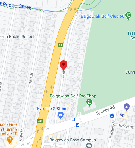
The Beaches Link still calls for the residential properties along Dudley Street to be resumed to allow for the widening of the Burnt Bridge Creek Deviation, the tunnel portal and motorway facilities. As has been known for some time, Balgowlah Golf Course will be no more, though the EIS states 90 per cent of the land will be returned and made available for a wider variety of recreational facilities (to be decided down the line).
Overall the project has seen some improvements from the original design, the councillor, who is also the Chief Operating Officer at UNICEF, said.
“The entry of the tunnel is further south, and alignment of the tunnel is now under Sydney Road, under a commercial area rather than residences. This is a big improvement from the previous alignment under the houses near Seaforth Public school where the tunnelling was to be shallower.”
Unfiltered stacks a sticking point
The emissions stacks will be positioned fairly close to both Balgowlah Boys and Seaforth Public Schools. According to the report it’s cheaper and more sustainable (uses less power) to put the ventilation stacks nearer the tunnel openings.
Cr Grattan said the stacks are a key area of concern for her constituents.
“The Chief Scientist tells us we have nothing to be worried about but this is a very difficult thing to convince us of. Filtering the stacks seems prudent under the precautionary principle,” she said.
Filtration ‘not necessary’
The report confirms ventilation outlets and motorway facilities at the Warringah Freeway in Cammeray, the Gore Hill Freeway in Artarmon, Burnt Bridge Creek Deviation in Balgowlah and Wakehurst Parkway in Killarney Heights.
The report states that extensive air quality modelling has been carried out and that, “Under expected traffic conditions, the predicted contribution of tunnel ventilation outlets to pollutant concentrations at ground level was negligible for all receptors.”
It also points to a recent report by the State’s Chief Scientist which found that emissions from well-designed road tunnels cause a “a negligible change to surrounding air quality.”
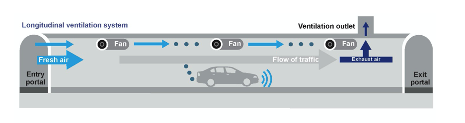
The report says its preferred ventilation system is a “longitudinal system with elevated ventilation outlets”. While this was once considered unsuitable for longer tunnels, it says improvements to vehicle emissions make it feasible and able to meet required standards.
It’s also cheaper than transverse systems, which add in fresh air through ducts.
“The inclusion of filtration would result in no material change in air quality in the surrounding community when compared to the current project ventilation system and outlet design,” the report concludes. “Any predicted changes in the concentration of pollutants would be largely driven by changes in the surface road traffic.”
A stickler for details?
For more info on ventilation stacks go to chapter 4 page 80 of the EIS.
And chapter 12 page 26.
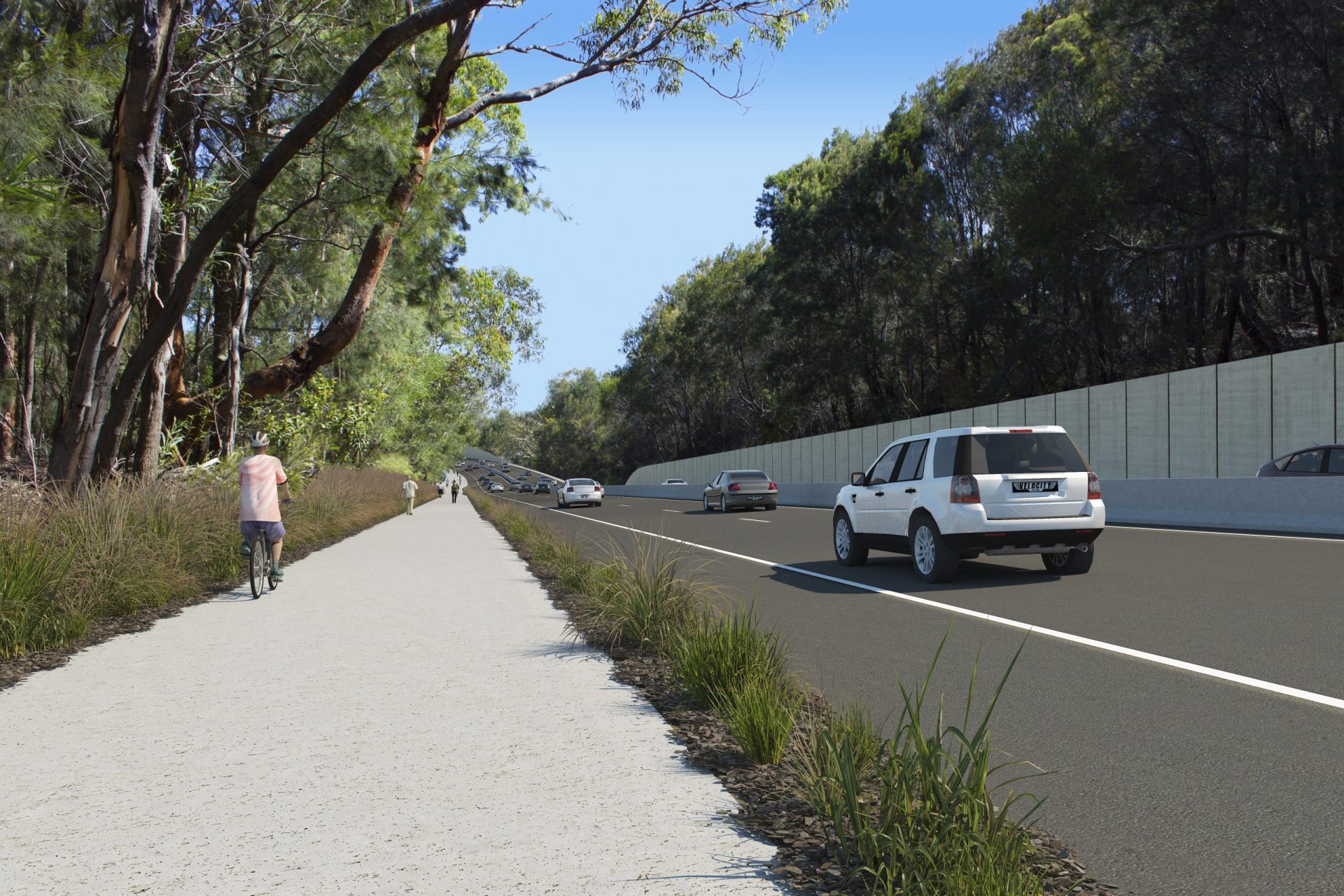
Wakehurst widening pros and cons
The widening of the Wakehurst Parkway will result in loss of trees, and the EIS recognises there are many risks to the Manly Dam catchment to be managed, as well as Indigenous heritage sites to be protected.
Cr Grattan said that North Balgowlah residents will have to endure a number of access restrictions during construction and their view will be of construction screens for some time.
“But on the on the upside, additional pedestrian, cycling and fauna crossings have been included across the widened Wakehurst Parkway,” she said.
The benefits of widening the Wakehurst Parkway, according to the report, will be the shared path with overpass links to the new Northern Beaches Hospital precinct, and shared user underpasses provided beneath Wakehurst Parkway to provide safe connections from Garigal National Park and Manly Dam Reserve.
However, the report confirms that over 15 hectares of native vegetation will be removed across the project areas, including some threatened flora species as well as potential habitats for threatened fauna species.
There may also be effects to the groundwater system, which can have flow on issues for ecosystems that rely on it.
During the construction period, there are also potential noise impacts on the Grey-headed Flying-fox camp located in the vegetated area between Balgowlah Road and the Burnt Bridge Creek Deviation (about 120 metres from the surface road works at Balgowlah), fauna in the vicinity of the Wakehurst Parkway during excavation activities and Little Penguins that visit Middle Harbour on occasion.
Where do I go if I want to have a say or ask further questions?
During the exhibition period, a project information line (1800 931 189) and email address (whtbl@transport.nsw.gov.au) will be available for the community and stakeholders.
Written submissions can be made to the Secretary of the Department of Planning, Industry and Environment. All submissions received will be placed on the Department of Planning, Industry and Environment website.
Submissions can also be made by creating an account at www.planningportal.nsw.gov.au/major- projects/projects/on-exhibition. This allows you to save a submission in progress and stay up to date with the progress of an application.
There will be virtual information sessions on the following dates:
• Artarmon 4pm-5pm, Thursday 14 January
• Cammeray 5.30pm-7pm, Thursday 14 January
• Northbridge/Willoughby 4pm – 5.30pm, Tuesday 19 January
• Seaforth/Killarney Heights/Frenchs Forest 6pm-7:30pm, Tuesday 19 January
• Mosman/Middle Harbour 4pm – 5.30pm, Wednesday 20 January
• Balgowlah 6pm-7.30pm, Wednesday 20 January
For more information go to: https://www.planningportal.nsw.gov.au/major-projects/project/10456
