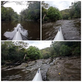
The tsunamis around the Pacific Ocean, caused by the eruption of the Hunga-Tonga-Hunga-Ha’apai volcano in the Tonga archipelago on Saturday 15 January, led to a tidal surge that was recorded in the upper reaches of Middle Harbour Creek, near St Ives.
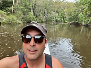
Ironically, the event was documented by an expert in marine water study, Will Glamore, a tidal scientist at the Water Research Laboratory in Manly Vale. Glamore happened to be paddling his surf-ski in Middle Harbour Creek when the surge rolled in the morning after the volcano erupted. He was 3,600km away from the epicentre of the blast.
Glamore told Manly Observer, “I was paddling my surf-ski and noticed the current was abnormally strong. All of a sudden the river fell a meter and I was stranded above the rocks, holding on against the current for 10 minutes. Then, just as quickly, the tide changed and it started rushing in…”
Glamore was at the tidal reaches of Middle Harbour Creek at the time, near Bungaroo in Garigal National Park, where the seawater meets the fresh water from upstream. Video footage recorded on his Go-Pro camera reveals the creek water flowing out abnormally fast, then, around 10 minutes later, reversing current and surging back.
“Normally the tide goes up and down, but there’s not a lot of water moving,” Glamore said. “But on this occasion the water was flying, racing upstream quickly, and really high, as high as the highest tide I’ve ever seen there!
“I hadn’t thought it was a tsunami at this stage… I reached the top, about 5km upstream from Roseville Bridge, and thought the water was unusually high, as I’d not paddled there that easily before. I turned around and started paddling back when all of a sudden the water just fell out from underneath me. The water dropped a metre or so in less than 10 minutes.”
Glamore was isolated on a rock ledge as what was previously a navigable stream became a bed of rocks exposed by the retreating tide. After 10 minutes, during which he considered how to carry his six-metre-long surf-ski back to somewhere he could paddle safely without cracking the hull, the water came rushing back.
“The seawater rushed up even faster than before. The creek rose a metre in less than two minutes! All the rocks that had just been exposed were submerged again.”

Eruption disruption
The Hunga-Tonga-Hunga-Ha’apai volcano, located about 65km north of Tongatapu (the main island in the archipelago of Tonga where the capital Nuku’alofa is sited), began erupting on 20 Dec 2021 after lying dormant for years. On 13 Jan, the submarine volcano spewed an ash cloud 17km into the atmosphere, and tsunami warnings were issued around the Pacific Ocean in anticipation of a major eruption.
Two days later, the volcano exploded, sending a plume of ash, gas and steam an estimated 30km high, and triggering tidal surges that were recorded as far away as Alaska and Peru, where two women were swept off a beach to their deaths. Waves as high as 2.7m were reported in Iwate, north-eastern Japan.
The Australian Bureau of Meteorology recorded a 1.2 metre tsunami crashed into Nuku’alofa around 5.30pm local time on Saturday, destroying marinas, resorts and seafront properties, washing boats and boulders ashore.
Early reports indicate that Tongatapu’s entire west coast was impacted, with Kanukupolu village inundated and demolished by the tidal surge. Parts of the capital were flooded, including the Royal Palace, precipitating the evacuation of Tonga’s King Tupou VI. Tragically, a British woman was dragged out to sea with her collection of dogs, and lost.

Preparations for the future
According to the Bureau of Meteorology, “Australia is bounded on the northwest, northeast and east by some 8,000 km of active tectonic plate boundary capable of generating a tsunami, which could reach our coastline within two to four hours. One-third of all earthquakes worldwide occur along these boundaries. The impact of a tsunami hitting vulnerable low-lying areas of the Australian coast could be significant.”
Sydney suburb Clontarf experienced significant tidal erosion of its foreshores following the 22 May 1960 Chile earthquake – the most powerful earthquake in recorded history – which took place 10,632km away.
On 26 Dec 2004 an earthquake off the west coast of Northern Sumatra, Indonesia, measuring an extreme 9.1 magnitude, caused massive devastation and loss of life – one of the deadliest natural disasters in recorded history. The tsunamis it triggered, with waves over 12m (extending to 30m high when they reached land), and travelling at speeds up to 800km/h, crashed into coastal communities around the Indian Ocean, killing an estimated 227,898 people in 14 countries.
As a result, the Australian Govt established the Australian Tsunami Warning System, a collaboration between several agencies and utilising ocean buoys and other detection equipment, to deliver comprehensive advance warnings of possible tsunamis.
According to data released by the National Oceanic and Atmospheric Administration, there have been approximately 300 tsunami events worldwide since 2001.
Rising sea levels caused by global warming will also have a significant impact on Australia’s coastline, especially in tidal estuaries, where sea water is concentrated, enabling it to flow in and out very quickly.
“We often only focus on our ocean beaches, but the number of people who were in the tidal creeks, rivers and harbours when the Tongan tsunami reached Australia was enormous,” Will Glamore revealed. “We tell people to watch out for what is happening in the ocean, but most people live – and play – in our estuaries and harbours.
“One of the things in which I specialise are the impacts of sea level rises in our estuaries. It’s a huge issue in that we have over 50,000 properties at risk in our estuaries in NSW, while there’s maybe 500 along the coastline. If you look at the rise in our oceans, all those backwater sites are at risk.”
And not just properties and shorelines are vulnerable. Marine life is also impacted by tidal surges, as Glamore observed during his excursion up Middle Harbour Creek.
“Another interesting thing I noticed,” Glamore continued, “because the velocity of the water was moving so fast, it was scouring out the dirt along the bottom of the river. The water became really dense with the turbidity of all the stuff churned up in it.
“In turn, that was displacing all the oxygen in the water, and while I was paddling up and down the creek, a lot of fish were gulping at the surface, because there was no oxygen left below; they were struggling to breathe.”
With fish and marine life suffocating as a result of the Tongan tsunami, swimmers and water enthusiasts should take extreme care around the mouths of tidal rivers in the aftermath – dead creatures washing downstream will attract hungry sharks.
Link to Will Glamore’s film footage, sped up 6x
https://www.linkedin.com/feed/update/urn:li:activity:6888434786759774208/
Australian Tsunami Warning System
http://www.bom.gov.au/tsunami/about/atws.shtml

=======================


